


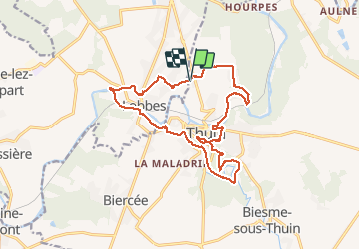
Rando autour de Thuin

Nicolas Guerlement
User


3h30
Difficulty : Medium

FREE GPS app for hiking
 SityTrail
IGN / Geographical institutes
SityTrail Plus
The world is yours!
About
Trail On foot of 16.4 km to be discovered at Wallonia, Hainaut, Thuin. This trail is proposed by Nicolas Guerlement.
Description
Une randonnée à la découverte des petites voiries et dans des paysages variées (sentier, ruelles, bois, halage, rue pittoresque...).
Possibilité de pique-niquer à plusieurs endroits du parcours avec vue sur le val de Sambre.
Positioning
Comments