


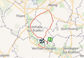
verchain maugre par maing

BrassensJC
User

Length
11.3 km

Max alt
82 m

Uphill gradient
103 m
Km-Effort
12.7 km

Min alt
34 m

Downhill gradient
106 m
Boucle
No
Creation date :
2020-05-19 09:11:10.551
Updated on :
2020-05-19 12:30:32.071
2h40
Difficulty : Easy

FREE GPS app for hiking
 SityTrail
IGN / Geographical institutes
SityTrail Plus
The world is yours!
About
Trail Walking of 11.3 km to be discovered at Hauts-de-France, Nord, Verchain-Maugré. This trail is proposed by BrassensJC.
Photos

Positioning
Country:
France
Region :
Hauts-de-France
Department/Province :
Nord
Municipality :
Verchain-Maugré
Location:
Unknown
Start:(Dec)
Start:(UTM)
534184 ; 5568808 (31U) N.
Comments