


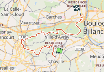
De Saint Cloud à Chaville

jpcccb
User

Length
14.5 km

Max alt
182 m

Uphill gradient
237 m
Km-Effort
17.7 km

Min alt
59 m

Downhill gradient
267 m
Boucle
No
Creation date :
2020-05-19 14:57:45.786
Updated on :
2023-05-01 15:30:24.471
4h01
Difficulty : Easy

FREE GPS app for hiking
 SityTrail
IGN / Geographical institutes
SityTrail Plus
The world is yours!
About
Trail On foot of 14.5 km to be discovered at Ile-de-France, Hauts-de-Seine, Chaville. This trail is proposed by jpcccb.
Positioning
Country:
France
Region :
Ile-de-France
Department/Province :
Hauts-de-Seine
Municipality :
Chaville
Location:
Unknown
Start:(Dec)
Start:(UTM)
440372 ; 5406889 (31U) N.
Comments