


sortie dom thurin

coco1409
User
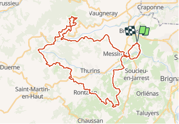

Length
52 km

Max alt
805 m

Uphill gradient
1422 m
Km-Effort
71 km

Min alt
251 m

Downhill gradient
1421 m
Boucle
Yes
Creation date :
2020-05-19 11:39:39.815
Updated on :
2020-05-19 15:34:05.641
3h52
Difficulty : Medium

FREE GPS app for hiking
 SityTrail
IGN / Geographical institutes
SityTrail Plus
The world is yours!
About
Trail Mountain bike of 52 km to be discovered at Auvergne-Rhône-Alpes, Rhône, Brindas. This trail is proposed by coco1409.
Positioning
Country:
France
Region :
Auvergne-Rhône-Alpes
Department/Province :
Rhône
Municipality :
Brindas
Location:
Unknown
Start:(Dec)
Start:(UTM)
632697 ; 5063182 (31T) N.
Comments