


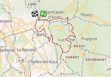
Circuit Leysse-Trou Enfer-Puygros-Terneze-Curienne-Mont St Michel-Barby

Valmeinier
User

Length
18.4 km

Max alt
879 m

Uphill gradient
858 m
Km-Effort
30 km

Min alt
306 m

Downhill gradient
859 m
Boucle
Yes
Creation date :
2020-05-20 05:33:16.838
Updated on :
2021-04-17 09:10:35.479
--
Difficulty : Unknown

FREE GPS app for hiking
 SityTrail
IGN / Geographical institutes
SityTrail Plus
The world is yours!
About
Trail Walking of 18.4 km to be discovered at Auvergne-Rhône-Alpes, Savoy, Saint-Jean-d'Arvey. This trail is proposed by Valmeinier.
Positioning
Country:
France
Region :
Auvergne-Rhône-Alpes
Department/Province :
Savoy
Municipality :
Saint-Jean-d'Arvey
Location:
Unknown
Start:(Dec)
Start:(UTM)
732364 ; 5051841 (31T) N.
Comments