


Lac NOIR Chemin des Charbonniers-Spots Sabots

Valmeinier
User
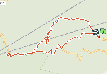

Length
7.5 km

Max alt
1016 m

Uphill gradient
416 m
Km-Effort
13 km

Min alt
657 m

Downhill gradient
415 m
Boucle
Yes
Creation date :
2020-05-20 05:33:18.034
Updated on :
2021-04-20 08:33:22.08
--
Difficulty : Unknown

FREE GPS app for hiking
 SityTrail
IGN / Geographical institutes
SityTrail Plus
The world is yours!
About
Trail Walking of 7.5 km to be discovered at Auvergne-Rhône-Alpes, Isère, Chapareillan. This trail is proposed by Valmeinier.
Positioning
Country:
France
Region :
Auvergne-Rhône-Alpes
Department/Province :
Isère
Municipality :
Chapareillan
Location:
Unknown
Start:(Dec)
Start:(UTM)
730361 ; 5040578 (31T) N.
Comments