Trail Walking Rustrel - Rustrel - La grand-Montagne - Photo

Rustrel - La grand-Montagne

© OpenStreetMap contributors
Length
Length
11.6 km
Max alt
Max alt
1040 m
Uphill gradient
Uphill gradient
682 m
Km-Effort
Km-Effort  
21 km
Min alt
Min alt
434 m
Downhill gradient
Downhill gradient
638 m
Boucle
Boucle
Yes
Creation date :
2020-05-20 05:24:32.141
Updated on :
2020-06-13 13:56:45.332

(0 Reviews)

Walking
Walking
3h36
Difficulty : Difficult

Scan this QR Code to open this trail in the SityTrail application

FREE GPS app for hiking

Logo SityTrail SityTrail

IGN / Geographical institutes

Download SityTrail from the App Store Download SityTrail from Google Play

Logo SityTrail SityTrail Plus

The world is yours!

Download SityTrail from the App Store Download SityTrail from Google Play Download SityTrail on Huawei AppGallery

About

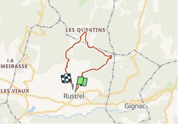
Trail Walking of 11.6 km to be discovered at Provence-Alpes-Côte d'Azur, Vaucluse, Rustrel. This trail is proposed by MarcLEBARON.

Description

Boucle.
Stationnement au cimetière. Montée par la combe de caucaille jusqu'au Suif (le matin sangliers et chevreuils visibles aux Jas. Poursuite vers les Quintins (attention troupeaux et chiens de protection, possibilité d'évitement en logeant la clôture avant Méri. Poursuite vers le ravin l'Aygue et secteur hors sentier pour rejoindre les éperons rocheux dessous grand-Montagne jusqu'à Rustrel.

Elevation profile

Positioning

Country:
France
Region :
Provence-Alpes-Côte d'Azur
Department/Province :
Vaucluse
Municipality :
Rustrel
Location:
Unknown
Start:(UTM)
699513 ; 4866669 (31T) N.


Close
My subscriptions