


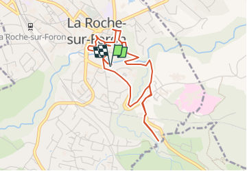
TOUR DE LA ROCHE-SUR-FORON

COMAN
User

Length
4.6 km

Max alt
585 m

Uphill gradient
111 m
Km-Effort
6.1 km

Min alt
522 m

Downhill gradient
110 m
Boucle
Yes
Creation date :
2014-12-10 00:00:00.0
Updated on :
2014-12-10 00:00:00.0
2h00
Difficulty : Very easy

FREE GPS app for hiking
 SityTrail
IGN / Geographical institutes
SityTrail Plus
The world is yours!
About
Trail Walking of 4.6 km to be discovered at Auvergne-Rhône-Alpes, Upper Savoy, La Roche-sur-Foron. This trail is proposed by COMAN.
Description
Découverte du Château jusqu’à la bénite fontaine en passant dans les méandres de la ville
Positioning
Country:
France
Region :
Auvergne-Rhône-Alpes
Department/Province :
Upper Savoy
Municipality :
La Roche-sur-Foron
Location:
Unknown
Start:(Dec)
Start:(UTM)
292257 ; 5104672 (32T) N.
Comments