


savieres

DaVinci
User
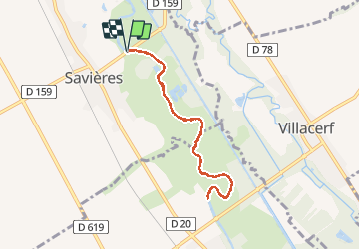

Length
7 km

Max alt
93 m

Uphill gradient
28 m
Km-Effort
7.4 km

Min alt
84 m

Downhill gradient
28 m
Boucle
Yes
Creation date :
2020-05-21 07:52:01.638
Updated on :
2020-05-21 10:01:48.046
2h08
Difficulty : Very easy

FREE GPS app for hiking
 SityTrail
IGN / Geographical institutes
SityTrail Plus
The world is yours!
About
Trail Canoe - kayak of 7 km to be discovered at Grand Est, Aube, Savières. This trail is proposed by DaVinci.
Positioning
Country:
France
Region :
Grand Est
Department/Province :
Aube
Municipality :
Savières
Location:
Unknown
Start:(Dec)
Start:(UTM)
570868 ; 5362308 (31U) N.
Comments