


la chambotte

MarcVachet
User
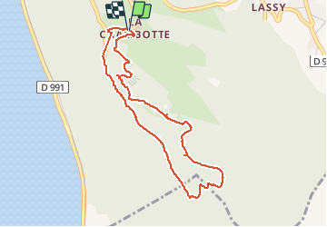

Length
4.4 km

Max alt
782 m

Uphill gradient
209 m
Km-Effort
7.2 km

Min alt
599 m

Downhill gradient
204 m
Boucle
Yes
Creation date :
2020-05-21 07:42:56.428
Updated on :
2020-05-21 10:31:46.829
1h54
Difficulty : Easy

FREE GPS app for hiking
 SityTrail
IGN / Geographical institutes
SityTrail Plus
The world is yours!
About
Trail Walking of 4.4 km to be discovered at Auvergne-Rhône-Alpes, Savoy, Entrelacs. This trail is proposed by MarcVachet.
Positioning
Country:
France
Region :
Auvergne-Rhône-Alpes
Department/Province :
Savoy
Municipality :
Entrelacs
Location:
Saint-Germain-la-Chambotte
Start:(Dec)
Start:(UTM)
723492 ; 5073286 (31T) N.
Comments