


les Vignottes 1

MoiClaude
User

Length
916 m

Max alt
110 m

Uphill gradient
4 m
Km-Effort
969 m

Min alt
105 m

Downhill gradient
4 m
Boucle
No
Creation date :
2020-05-21 14:36:27.018
Updated on :
2020-05-21 15:48:27.324
11m
Difficulty : Very easy

FREE GPS app for hiking
 SityTrail
IGN / Geographical institutes
SityTrail Plus
The world is yours!
About
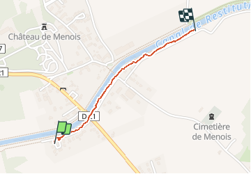
Trail Walking of 916 m to be discovered at Grand Est, Aube, Rouilly-Saint-Loup. This trail is proposed by MoiClaude.
Description
Tour de Rouilly
Positioning
Country:
France
Region :
Grand Est
Department/Province :
Aube
Municipality :
Rouilly-Saint-Loup
Location:
Unknown
Start:(Dec)
Start:(UTM)
584306 ; 5346535 (31U) N.
Comments