


lolotte

lunikodacious
User
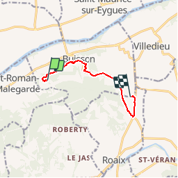

Length
7.2 km

Max alt
278 m

Uphill gradient
111 m
Km-Effort
8.8 km

Min alt
192 m

Downhill gradient
139 m
Boucle
No
Creation date :
2014-12-10 00:00:00.0
Updated on :
2014-12-10 00:00:00.0
--
Difficulty : Very easy

FREE GPS app for hiking
 SityTrail
IGN / Geographical institutes
SityTrail Plus
The world is yours!
About
Trail Walking of 7.2 km to be discovered at Provence-Alpes-Côte d'Azur, Vaucluse, Buisson. This trail is proposed by lunikodacious.
Description
jardijon les champs
Positioning
Country:
France
Region :
Provence-Alpes-Côte d'Azur
Department/Province :
Vaucluse
Municipality :
Buisson
Location:
Unknown
Start:(Dec)
Start:(UTM)
658171 ; 4903972 (31T) N.
Comments