


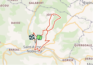
Saint Antonin pr17

Glurps
User

Length
15.7 km

Max alt
359 m

Uphill gradient
420 m
Km-Effort
21 km

Min alt
130 m

Downhill gradient
422 m
Boucle
Yes
Creation date :
2020-05-22 09:53:04.0
Updated on :
2020-05-22 15:25:35.423
4h51
Difficulty : Difficult

FREE GPS app for hiking
 SityTrail
IGN / Geographical institutes
SityTrail Plus
The world is yours!
About
Trail Walking of 15.7 km to be discovered at Occitania, Tarn-et-Garonne, Saint-Antonin-Noble-Val. This trail is proposed by Glurps.
Description
Une petite échelle et quelques montées raides
Positioning
Country:
France
Region :
Occitania
Department/Province :
Tarn-et-Garonne
Municipality :
Saint-Antonin-Noble-Val
Location:
Unknown
Start:(Dec)
Start:(UTM)
400672 ; 4890205 (31T) N.
Comments