


crouy blaincourt ercuis

Djaie60
User
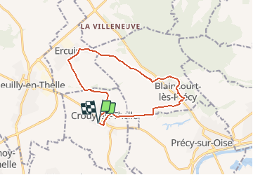

Length
12.4 km

Max alt
144 m

Uphill gradient
168 m
Km-Effort
14.7 km

Min alt
52 m

Downhill gradient
166 m
Boucle
Yes
Creation date :
2020-05-22 15:50:09.286
Updated on :
2020-05-22 15:51:04.968
--
Difficulty : Very easy

FREE GPS app for hiking
 SityTrail
IGN / Geographical institutes
SityTrail Plus
The world is yours!
About
Trail On foot of 12.4 km to be discovered at Hauts-de-France, Oise, Crouy-en-Thelle. This trail is proposed by Djaie60.
Positioning
Country:
France
Region :
Hauts-de-France
Department/Province :
Oise
Municipality :
Crouy-en-Thelle
Location:
Unknown
Start:(Dec)
Start:(UTM)
450447 ; 5451300 (31U) N.
Comments