


2020 05 Cheptainville T1

michel1025
User
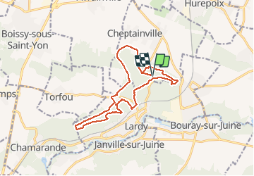

Length
14.7 km

Max alt
163 m

Uphill gradient
293 m
Km-Effort
18.6 km

Min alt
85 m

Downhill gradient
292 m
Boucle
Yes
Creation date :
2020-05-22 12:41:36.0
Updated on :
2020-05-22 16:16:56.373
2h51
Difficulty : Unknown

FREE GPS app for hiking
 SityTrail
IGN / Geographical institutes
SityTrail Plus
The world is yours!
About
Trail Walking of 14.7 km to be discovered at Ile-de-France, Essonne, Cheptainville. This trail is proposed by michel1025.
Positioning
Country:
France
Region :
Ile-de-France
Department/Province :
Essonne
Municipality :
Cheptainville
Location:
Unknown
Start:(Dec)
Start:(UTM)
446353 ; 5376184 (31U) N.
Comments