


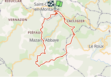
St Cirgues en Montagne 18km

thonyc
User GUIDE

Length
18 km

Max alt
1339 m

Uphill gradient
535 m
Km-Effort
25 km

Min alt
1055 m

Downhill gradient
533 m
Boucle
Yes
Creation date :
2020-05-22 07:31:21.816
Updated on :
2020-06-19 16:23:19.855
8h48
Difficulty : Difficult

FREE GPS app for hiking
 SityTrail
IGN / Geographical institutes
SityTrail Plus
The world is yours!
About
Trail Walking of 18 km to be discovered at Auvergne-Rhône-Alpes, Ardèche, Saint-Cirgues-en-Montagne. This trail is proposed by thonyc.
Positioning
Country:
France
Region :
Auvergne-Rhône-Alpes
Department/Province :
Ardèche
Municipality :
Saint-Cirgues-en-Montagne
Location:
Unknown
Start:(Dec)
Start:(UTM)
587204 ; 4956018 (31T) N.
Comments