


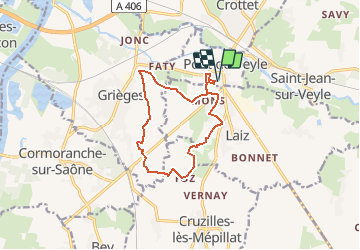
Rando autour de Pont de Veyle

janussity
User

Length
11.8 km

Max alt
211 m

Uphill gradient
84 m
Km-Effort
12.9 km

Min alt
171 m

Downhill gradient
84 m
Boucle
Yes
Creation date :
2020-05-24 11:59:10.517
Updated on :
2020-05-24 12:02:23.226
--
Difficulty : Very easy

FREE GPS app for hiking
 SityTrail
IGN / Geographical institutes
SityTrail Plus
The world is yours!
About
Trail On foot of 11.8 km to be discovered at Auvergne-Rhône-Alpes, Ain, Pont-de-Veyle. This trail is proposed by janussity.
Description
faite le 24 mai 2020 avec les Henri par temps ensoleillé agréable à 21°C.
PdV,Faty( Grièges) Courcelles, Foz, Laiz Malivert.
11.77 km
Positioning
Country:
France
Region :
Auvergne-Rhône-Alpes
Department/Province :
Ain
Municipality :
Pont-de-Veyle
Location:
Unknown
Start:(Dec)
Start:(UTM)
645359 ; 5124560 (31T) N.
Comments