


*Forêts de Dourdan et de St Arnoult

jpcccb
User
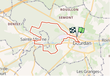

Length
14.2 km

Max alt
172 m

Uphill gradient
203 m
Km-Effort
16.9 km

Min alt
94 m

Downhill gradient
202 m
Boucle
Yes
Creation date :
2020-05-24 14:10:34.817
Updated on :
2024-07-10 08:13:45.447
3h49
Difficulty : Easy

FREE GPS app for hiking
 SityTrail
IGN / Geographical institutes
SityTrail Plus
The world is yours!
About
Trail On foot of 14.2 km to be discovered at Ile-de-France, Essonne, Dourdan. This trail is proposed by jpcccb.
Positioning
Country:
France
Region :
Ile-de-France
Department/Province :
Essonne
Municipality :
Dourdan
Location:
Unknown
Start:(Dec)
Start:(UTM)
426896 ; 5376061 (31U) N.
Comments