


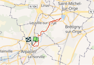
bord de l'orge

jchezlemas
User

Length
10.8 km

Max alt
63 m

Uphill gradient
79 m
Km-Effort
11.8 km

Min alt
39 m

Downhill gradient
79 m
Boucle
Yes
Creation date :
2020-05-24 14:23:38.155
Updated on :
2020-05-24 16:47:36.42
2h23
Difficulty : Easy

FREE GPS app for hiking
 SityTrail
IGN / Geographical institutes
SityTrail Plus
The world is yours!
About
Trail Walking of 10.8 km to be discovered at Ile-de-France, Essonne, Saint-Germain-lès-Arpajon. This trail is proposed by jchezlemas.
Positioning
Country:
France
Region :
Ile-de-France
Department/Province :
Essonne
Municipality :
Saint-Germain-lès-Arpajon
Location:
Unknown
Start:(Dec)
Start:(UTM)
444958 ; 5382809 (31U) N.
Comments