


tonne le t

Claude Luchetta
User

Length
25 km

Max alt
356 m

Uphill gradient
608 m
Km-Effort
33 km

Min alt
160 m

Downhill gradient
525 m
Boucle
No
Creation date :
2020-05-25 11:00:18.697
Updated on :
2020-05-25 15:00:34.749
2h59
Difficulty : Very easy

FREE GPS app for hiking
 SityTrail
IGN / Geographical institutes
SityTrail Plus
The world is yours!
About
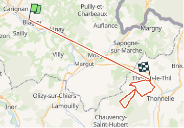
Trail Walking of 25 km to be discovered at Grand Est, Ardennes, Blagny. This trail is proposed by Claude Luchetta.
Positioning
Country:
France
Region :
Grand Est
Department/Province :
Ardennes
Municipality :
Blagny
Location:
Unknown
Start:(Dec)
Start:(UTM)
657901 ; 5498931 (31U) N.
Comments