


Mont Myon à Chevignat-Pressiat

janussity
User
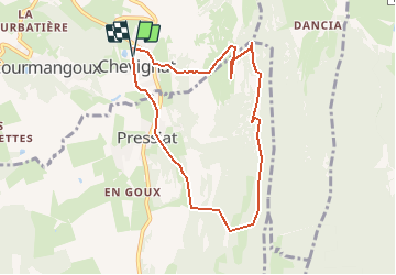

Length
7.9 km

Max alt
652 m

Uphill gradient
481 m
Km-Effort
14.3 km

Min alt
305 m

Downhill gradient
480 m
Boucle
Yes
Creation date :
2020-05-26 07:22:51.926
Updated on :
2020-05-26 07:24:47.111
--
Difficulty : Medium

FREE GPS app for hiking
 SityTrail
IGN / Geographical institutes
SityTrail Plus
The world is yours!
About
Trail On foot of 7.9 km to be discovered at Auvergne-Rhône-Alpes, Ain, Courmangoux. This trail is proposed by janussity.
Description
Rando facile un peu de dénivellé dans le Revermont.
Positioning
Country:
France
Region :
Auvergne-Rhône-Alpes
Department/Province :
Ain
Municipality :
Courmangoux
Location:
Unknown
Start:(Dec)
Start:(UTM)
683405 ; 5133665 (31T) N.
Comments