Mont Myon-Revermint

janussity
User
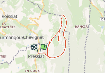

Length
7 km

Max alt
657 m

Uphill gradient
319 m
Km-Effort
11.3 km

Min alt
350 m

Downhill gradient
322 m
Boucle
Yes
Creation date :
2020-05-26 09:56:26.958
Updated on :
2020-05-26 14:25:11.67
2h08
Difficulty : Medium

FREE GPS app for hiking
 SityTrail
IGN / Geographical institutes
SityTrail Plus
The world is yours!
About
Trail Walking of 7 km to be discovered at Auvergne-Rhône-Alpes, Ain, Val-Revermont. This trail is proposed by janussity.
Description
Belle journée ensoleillée..21°C.
Montée raide depuis Pressiat sur un chemin terre-pierre. Belle végétation et fleurs...
Photos


Positioning
Country:
France
Region :
Auvergne-Rhône-Alpes
Department/Province :
Ain
Municipality :
Val-Revermont
Location:
Unknown
Start:(Dec)
Start:(UTM)
683754 ; 5132834 (31T) N.
Comments