


Col de l’echarasson avec Alice

alinetpierre
User
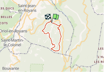

Length
10.2 km

Max alt
1165 m

Uphill gradient
414 m
Km-Effort
15.8 km

Min alt
838 m

Downhill gradient
413 m
Boucle
Yes
Creation date :
2020-05-27 08:46:56.0
Updated on :
2020-05-27 12:55:17.308
3h31
Difficulty : Unknown

FREE GPS app for hiking
 SityTrail
IGN / Geographical institutes
SityTrail Plus
The world is yours!
About
Trail Walking of 10.2 km to be discovered at Auvergne-Rhône-Alpes, Drôme, Saint-Jean-en-Royans. This trail is proposed by alinetpierre.
Description
Belle balade
Positioning
Country:
France
Region :
Auvergne-Rhône-Alpes
Department/Province :
Drôme
Municipality :
Saint-Jean-en-Royans
Location:
Unknown
Start:(Dec)
Start:(UTM)
682867 ; 4985920 (31T) N.
Comments