


hautil

Dayoff
User
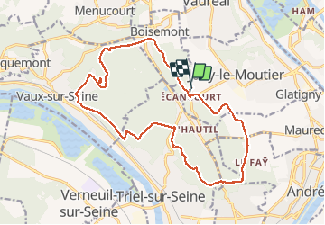

Length
18.2 km

Max alt
198 m

Uphill gradient
393 m
Km-Effort
23 km

Min alt
36 m

Downhill gradient
403 m
Boucle
Yes
Creation date :
2020-05-21 07:03:57.481
Updated on :
2020-05-28 07:09:04.64
5h07
Difficulty : Medium

FREE GPS app for hiking
 SityTrail
IGN / Geographical institutes
SityTrail Plus
The world is yours!
About
Trail Walking of 18.2 km to be discovered at Ile-de-France, Val-d'Oise, Jouy-le-Moutier. This trail is proposed by Dayoff.
Positioning
Country:
France
Region :
Ile-de-France
Department/Province :
Val-d'Oise
Municipality :
Jouy-le-Moutier
Location:
Unknown
Start:(Dec)
Start:(UTM)
427908 ; 5428706 (31U) N.
Comments