


Tracé

ZAMBAUX
User

Length
16.1 km

Max alt
304 m

Uphill gradient
297 m
Km-Effort
20 km

Min alt
209 m

Downhill gradient
297 m
Boucle
Yes
Creation date :
2020-05-28 10:32:39.533
Updated on :
2020-05-28 10:38:06.856
4h20
Difficulty : Very difficult

FREE GPS app for hiking
 SityTrail
IGN / Geographical institutes
SityTrail Plus
The world is yours!
About
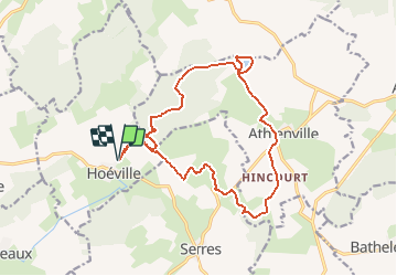
Trail Walking of 16.1 km to be discovered at Grand Est, Meurthe-et-Moselle, Hoéville. This trail is proposed by ZAMBAUX.
Description
dénivelé de 300m
Positioning
Country:
France
Region :
Grand Est
Department/Province :
Meurthe-et-Moselle
Municipality :
Hoéville
Location:
Unknown
Start:(Dec)
Start:(UTM)
311568 ; 5398300 (32U) N.
Comments