


guignicourt

Claude Luchetta
User
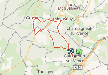

Length
15.2 km

Max alt
308 m

Uphill gradient
348 m
Km-Effort
19.8 km

Min alt
168 m

Downhill gradient
348 m
Boucle
Yes
Creation date :
2020-05-28 08:21:48.133
Updated on :
2020-05-28 13:29:48.533
5h06
Difficulty : Very easy

FREE GPS app for hiking
 SityTrail
IGN / Geographical institutes
SityTrail Plus
The world is yours!
About
Trail Walking of 15.2 km to be discovered at Grand Est, Ardennes, Guignicourt-sur-Vence. This trail is proposed by Claude Luchetta.
Positioning
Country:
France
Region :
Grand Est
Department/Province :
Ardennes
Municipality :
Guignicourt-sur-Vence
Location:
Unknown
Start:(Dec)
Start:(UTM)
619114 ; 5504416 (31U) N.
Comments