


2020 05 Champceuil T 1

michel1025
User
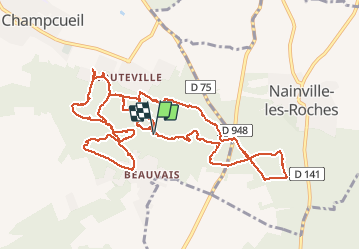

Length
14.2 km

Max alt
146 m

Uphill gradient
234 m
Km-Effort
17.3 km

Min alt
81 m

Downhill gradient
236 m
Boucle
Yes
Creation date :
2020-05-28 07:57:52.0
Updated on :
2020-05-28 13:58:51.798
4h53
Difficulty : Unknown

FREE GPS app for hiking
 SityTrail
IGN / Geographical institutes
SityTrail Plus
The world is yours!
About
Trail Walking of 14.2 km to be discovered at Ile-de-France, Essonne, Champcueil. This trail is proposed by michel1025.
Positioning
Country:
France
Region :
Ile-de-France
Department/Province :
Essonne
Municipality :
Champcueil
Location:
Unknown
Start:(Dec)
Start:(UTM)
460794 ; 5372226 (31U) N.
Comments