


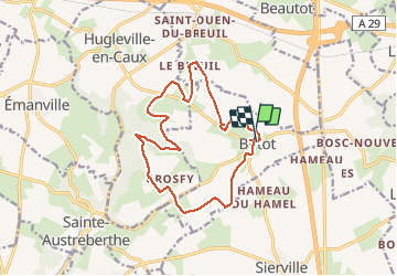
Butot -76- Chemin de randonnée le BOis de Grosfy

MichelRando7656
User


4h03
Difficulty : Difficult

FREE GPS app for hiking
 SityTrail
IGN / Geographical institutes
SityTrail Plus
The world is yours!
About
Trail Walking of 14.5 km to be discovered at Normandy, Seine-Maritime, Butot. This trail is proposed by MichelRando7656.
Description
Chemins de campagne et forestiers.
Petites routes campagnardes bien tranquilles.
Dommage que le parcours se termine par la D467 avec plus de. voitures.
Le passage par le GR 21-2 est peu pratiquable entre Saint-Ouen du Breuil et Butot. Arbres tombés chemin envahi et colonisé.
Photos


Positioning
Comments