


volvic Charbonniéres les Varennes Volvic

jeanic63
User
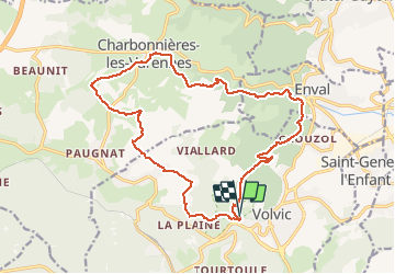

Length
19 km

Max alt
797 m

Uphill gradient
477 m
Km-Effort
25 km

Min alt
488 m

Downhill gradient
478 m
Boucle
Yes
Creation date :
2020-05-28 18:44:23.417
Updated on :
2020-07-31 15:12:35.292
--
Difficulty : Medium

FREE GPS app for hiking
 SityTrail
IGN / Geographical institutes
SityTrail Plus
The world is yours!
About
Trail On foot of 19 km to be discovered at Auvergne-Rhône-Alpes, Puy-de-Dôme, Volvic. This trail is proposed by jeanic63.
Description
Départ parking des sources de volvic
Positioning
Country:
France
Region :
Auvergne-Rhône-Alpes
Department/Province :
Puy-de-Dôme
Municipality :
Volvic
Location:
Unknown
Start:(Dec)
Start:(UTM)
502111 ; 5079835 (31T) N.
Comments