


10436220-track-1590739354-540

RenaudCandottiBesson
User
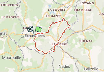

Length
11.6 km

Max alt
739 m

Uphill gradient
291 m
Km-Effort
15.5 km

Min alt
563 m

Downhill gradient
294 m
Boucle
Yes
Creation date :
2020-05-29 08:05:26.916
Updated on :
2020-05-29 08:05:26.916

FREE GPS app for hiking
 SityTrail
IGN / Geographical institutes
SityTrail Plus
The world is yours!
About
Trail of 11.6 km to be discovered at Auvergne-Rhône-Alpes, Allier, Échassières. This trail is proposed by RenaudCandottiBesson.
Positioning
Country:
France
Region :
Auvergne-Rhône-Alpes
Department/Province :
Allier
Municipality :
Échassières
Location:
Unknown
Start:(Dec)
Start:(UTM)
494887 ; 5114463 (31T) N.
Comments