


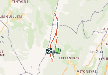
Le Col Vert

maupassant38
User

Length
11 km

Max alt
1746 m

Uphill gradient
572 m
Km-Effort
18.6 km

Min alt
1313 m

Downhill gradient
569 m
Boucle
Yes
Creation date :
2020-05-29 08:27:59.144
Updated on :
2020-06-01 14:13:04.827
2h37
Difficulty : Medium

FREE GPS app for hiking
 SityTrail
IGN / Geographical institutes
SityTrail Plus
The world is yours!
About
Trail Walking of 11 km to be discovered at Auvergne-Rhône-Alpes, Isère, Le Gua. This trail is proposed by maupassant38.
Positioning
Country:
France
Region :
Auvergne-Rhône-Alpes
Department/Province :
Isère
Municipality :
Le Gua
Location:
Unknown
Start:(Dec)
Start:(UTM)
704526 ; 4988098 (31T) N.
Comments