


tour du plateau des lacs

trailer38
User
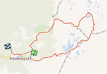

Length
11.7 km

Max alt
2133 m

Uphill gradient
533 m
Km-Effort
18.9 km

Min alt
1639 m

Downhill gradient
558 m
Boucle
No
Creation date :
2020-05-30 09:12:19.643
Updated on :
2020-05-30 16:57:19.357
5h19
Difficulty : Medium

FREE GPS app for hiking
 SityTrail
IGN / Geographical institutes
SityTrail Plus
The world is yours!
About
Trail Walking of 11.7 km to be discovered at Auvergne-Rhône-Alpes, Isère, Livet-et-Gavet. This trail is proposed by trailer38.
Description
tour du plateau des lacs
Positioning
Country:
France
Region :
Auvergne-Rhône-Alpes
Department/Province :
Isère
Municipality :
Livet-et-Gavet
Location:
Unknown
Start:(Dec)
Start:(UTM)
728913 ; 4992740 (31T) N.
Comments