


la mandallaz

COMAN
User
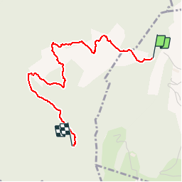

Length
3.2 km

Max alt
793 m

Uphill gradient
96 m
Km-Effort
4.3 km

Min alt
728 m

Downhill gradient
43 m
Boucle
No
Creation date :
2014-12-10 00:00:00.0
Updated on :
2014-12-10 00:00:00.0
1h22
Difficulty : Easy

FREE GPS app for hiking
 SityTrail
IGN / Geographical institutes
SityTrail Plus
The world is yours!
About
Trail Walking of 3.2 km to be discovered at Auvergne-Rhône-Alpes, Upper Savoy, Épagny Metz-Tessy. This trail is proposed by COMAN.
Description
au dessus d'Epany


Positioning
Country:
France
Region :
Auvergne-Rhône-Alpes
Department/Province :
Upper Savoy
Municipality :
Épagny Metz-Tessy
Location:
Unknown
Start:(Dec)
Start:(UTM)
273210 ; 5093826 (32T) N.
Comments