


Barberey savieres

DaVinci
User
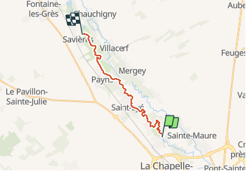

Length
14.6 km

Max alt
99 m

Uphill gradient
52 m
Km-Effort
15.4 km

Min alt
84 m

Downhill gradient
59 m
Boucle
No
Creation date :
2020-05-31 07:39:09.279
Updated on :
2020-05-31 09:52:02.54
2h11
Difficulty : Very easy

FREE GPS app for hiking
 SityTrail
IGN / Geographical institutes
SityTrail Plus
The world is yours!
About
Trail Canoe - kayak of 14.6 km to be discovered at Grand Est, Aube, Barberey-Saint-Sulpice. This trail is proposed by DaVinci.
Positioning
Country:
France
Region :
Grand Est
Department/Province :
Aube
Municipality :
Barberey-Saint-Sulpice
Location:
Unknown
Start:(Dec)
Start:(UTM)
576817 ; 5354790 (31U) N.
Comments