


Vallee du Neal

eric.deniau
User
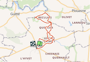

Length
15.1 km

Max alt
109 m

Uphill gradient
220 m
Km-Effort
18 km

Min alt
56 m

Downhill gradient
222 m
Boucle
Yes
Creation date :
2020-05-31 06:56:00.0
Updated on :
2020-05-31 10:30:15.437
3h33
Difficulty : Unknown

FREE GPS app for hiking
 SityTrail
IGN / Geographical institutes
SityTrail Plus
The world is yours!
About
Trail Walking of 15.1 km to be discovered at Brittany, Ille-et-Vilaine, Médréac. This trail is proposed by eric.deniau.
Positioning
Country:
France
Region :
Brittany
Department/Province :
Ille-et-Vilaine
Municipality :
Médréac
Location:
Unknown
Start:(Dec)
Start:(UTM)
569313 ; 5346136 (30U) N.
Comments