


La Mure

maupassant38
User
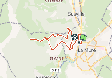

Length
9.3 km

Max alt
1195 m

Uphill gradient
356 m
Km-Effort
14.1 km

Min alt
873 m

Downhill gradient
355 m
Boucle
Yes
Creation date :
2020-05-31 08:17:03.91
Updated on :
2020-05-31 13:40:55.898
2h25
Difficulty : Easy

FREE GPS app for hiking
 SityTrail
IGN / Geographical institutes
SityTrail Plus
The world is yours!
About
Trail Walking of 9.3 km to be discovered at Auvergne-Rhône-Alpes, Isère, La Mure. This trail is proposed by maupassant38.
Positioning
Country:
France
Region :
Auvergne-Rhône-Alpes
Department/Province :
Isère
Municipality :
La Mure
Location:
Unknown
Start:(Dec)
Start:(UTM)
719693 ; 4976290 (31T) N.
Comments