


col de la Ruchere

CABERMAT
User
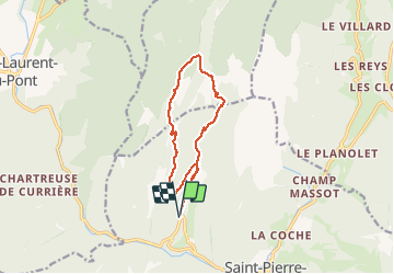

Length
12.3 km

Max alt
1532 m

Uphill gradient
714 m
Km-Effort
22 km

Min alt
841 m

Downhill gradient
719 m
Boucle
Yes
Creation date :
2020-05-31 08:20:01.646
Updated on :
2020-05-31 14:32:50.335
3h59
Difficulty : Very easy

FREE GPS app for hiking
 SityTrail
IGN / Geographical institutes
SityTrail Plus
The world is yours!
About
Trail Walking of 12.3 km to be discovered at Auvergne-Rhône-Alpes, Isère, Saint-Pierre-de-Chartreuse. This trail is proposed by CABERMAT.
Positioning
Country:
France
Region :
Auvergne-Rhône-Alpes
Department/Province :
Isère
Municipality :
Saint-Pierre-de-Chartreuse
Location:
Unknown
Start:(Dec)
Start:(UTM)
718361 ; 5026225 (31T) N.
Comments