


2010 05 Momenrencis T 1

michel1025
User
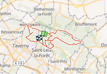

Length
18.9 km

Max alt
196 m

Uphill gradient
235 m
Km-Effort
22 km

Min alt
105 m

Downhill gradient
244 m
Boucle
No
Creation date :
2020-05-31 08:55:28.0
Updated on :
2020-05-31 15:09:19.143
4h48
Difficulty : Unknown

FREE GPS app for hiking
 SityTrail
IGN / Geographical institutes
SityTrail Plus
The world is yours!
About
Trail Walking of 18.9 km to be discovered at Ile-de-France, Val-d'Oise, Saint-Leu-la-Forêt. This trail is proposed by michel1025.
Positioning
Country:
France
Region :
Ile-de-France
Department/Province :
Val-d'Oise
Municipality :
Saint-Leu-la-Forêt
Location:
Unknown
Start:(Dec)
Start:(UTM)
444899 ; 5431143 (31U) N.
Comments