


VTT avec Alexandre

domifon
User

Length
25 km

Max alt
104 m

Uphill gradient
238 m
Km-Effort
28 km

Min alt
33 m

Downhill gradient
241 m
Boucle
Yes
Creation date :
2020-06-01 08:02:08.0
Updated on :
2020-06-01 09:40:34.686
1h37
Difficulty : Unknown

FREE GPS app for hiking
 SityTrail
IGN / Geographical institutes
SityTrail Plus
The world is yours!
About
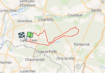
Trail Mountain bike of 25 km to be discovered at Hauts-de-France, Oise, Lamorlaye. This trail is proposed by domifon.
Positioning
Country:
France
Region :
Hauts-de-France
Department/Province :
Oise
Municipality :
Lamorlaye
Location:
Unknown
Start:(Dec)
Start:(UTM)
457655 ; 5445187 (31U) N.
Comments