


circuit du donon

fredodlageo
User
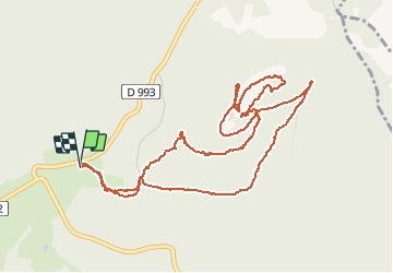

Length
6.1 km

Max alt
996 m

Uphill gradient
258 m
Km-Effort
9.6 km

Min alt
744 m

Downhill gradient
257 m
Boucle
Yes
Creation date :
2014-12-10 00:00:00.0
Updated on :
2014-12-10 00:00:00.0
1h26
Difficulty : Difficult

FREE GPS app for hiking
 SityTrail
IGN / Geographical institutes
SityTrail Plus
The world is yours!
About
Trail Walking of 6.1 km to be discovered at Grand Est, Bas-Rhin, Grandfontaine. This trail is proposed by fredodlageo.
Description
20140111
Photos


Positioning
Country:
France
Region :
Grand Est
Department/Province :
Bas-Rhin
Municipality :
Grandfontaine
Location:
Unknown
Start:(Dec)
Start:(UTM)
363337 ; 5374425 (32U) N.
Comments