


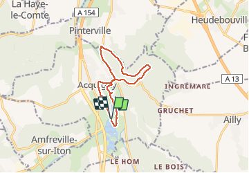
Acquigny. Du lac vers la forêt des Trévats

MichelRando7656
User

Length
10.5 km

Max alt
123 m

Uphill gradient
140 m
Km-Effort
12.4 km

Min alt
13 m

Downhill gradient
139 m
Boucle
Yes
Creation date :
2020-06-03 11:45:40.551
Updated on :
2020-06-03 14:42:10.776
2h55
Difficulty : Medium

FREE GPS app for hiking
 SityTrail
IGN / Geographical institutes
SityTrail Plus
The world is yours!
About
Trail Walking of 10.5 km to be discovered at Normandy, Eure, Acquigny. This trail is proposed by MichelRando7656.
Description
Chemins de ville à travers Acquigny et chemins forestiers. Passages en bordure de routes
Photos


Positioning
Country:
France
Region :
Normandy
Department/Province :
Eure
Municipality :
Acquigny
Location:
Unknown
Start:(Dec)
Start:(UTM)
367738 ; 5446961 (31U) N.
Comments