


Dinard

phi14
User
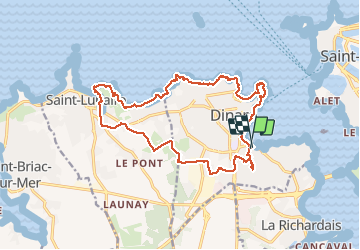

Length
17.8 km

Max alt
48 m

Uphill gradient
244 m
Km-Effort
21 km

Min alt
0 m

Downhill gradient
249 m
Boucle
Yes
Creation date :
2020-06-03 08:34:13.476
Updated on :
2020-09-14 13:25:02.479
6h03
Difficulty : Medium

FREE GPS app for hiking
 SityTrail
IGN / Geographical institutes
SityTrail Plus
The world is yours!
About
Trail Walking of 17.8 km to be discovered at Brittany, Ille-et-Vilaine, Dinard. This trail is proposed by phi14.
Description
Belle rando. Au km 1, j'ai du faire demi tour à cause de travaux, sinon il faut suivre le balisage jaune.
Positioning
Country:
France
Region :
Brittany
Department/Province :
Ille-et-Vilaine
Municipality :
Dinard
Location:
Unknown
Start:(Dec)
Start:(UTM)
569825 ; 5386134 (30U) N.
Comments