


laurabuc

leroj73
User
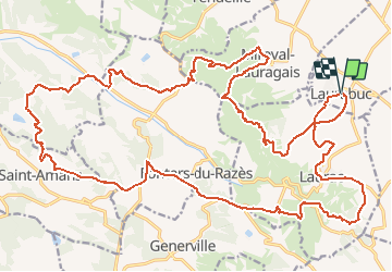

Length
36 km

Max alt
401 m

Uphill gradient
890 m
Km-Effort
48 km

Min alt
184 m

Downhill gradient
885 m
Boucle
Yes
Creation date :
2020-06-03 19:07:30.799
Updated on :
2020-06-03 19:14:08.658
3h07
Difficulty : Very difficult

FREE GPS app for hiking
 SityTrail
IGN / Geographical institutes
SityTrail Plus
The world is yours!
About
Trail Mountain bike of 36 km to be discovered at Occitania, Aude, Laurabuc. This trail is proposed by leroj73.
Description
départ laurabuc direction laurac/fontiers du razet/saint ama/miraval
Positioning
Country:
France
Region :
Occitania
Department/Province :
Aude
Municipality :
Laurabuc
Location:
Unknown
Start:(Dec)
Start:(UTM)
417297 ; 4788762 (31T) N.
Comments