


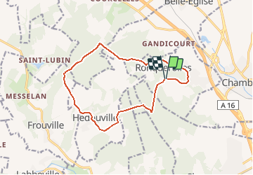
Ronquerolle 2 13km

Djaie60
User

Length
13.1 km

Max alt
174 m

Uphill gradient
262 m
Km-Effort
16.6 km

Min alt
65 m

Downhill gradient
263 m
Boucle
Yes
Creation date :
2020-06-04 17:14:40.0
Updated on :
2020-06-29 10:39:24.166
--
Difficulty : Very easy

FREE GPS app for hiking
 SityTrail
IGN / Geographical institutes
SityTrail Plus
The world is yours!
About
Trail On foot of 13.1 km to be discovered at Ile-de-France, Val-d'Oise, Ronquerolles. This trail is proposed by Djaie60.
Positioning
Country:
France
Region :
Ile-de-France
Department/Province :
Val-d'Oise
Municipality :
Ronquerolles
Location:
Unknown
Start:(Dec)
Start:(UTM)
442244 ; 5446371 (31U) N.
Comments