


le parc Lorient

raygautier
User
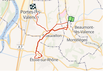

Length
18.3 km

Max alt
148 m

Uphill gradient
148 m
Km-Effort
20 km

Min alt
109 m

Downhill gradient
164 m
Boucle
No
Creation date :
2020-06-04 14:24:23.464
Updated on :
2020-06-04 18:47:18.586
2h35
Difficulty : Very easy

FREE GPS app for hiking
 SityTrail
IGN / Geographical institutes
SityTrail Plus
The world is yours!
About
Trail Walking of 18.3 km to be discovered at Auvergne-Rhône-Alpes, Drôme, Montéléger. This trail is proposed by raygautier.
Positioning
Country:
France
Region :
Auvergne-Rhône-Alpes
Department/Province :
Drôme
Municipality :
Montéléger
Location:
Unknown
Start:(Dec)
Start:(UTM)
651806 ; 4969850 (31T) N.
Comments