


VTT TB mais zone humide impossible en cas de pluie

domifon
User

Length
34 km

Max alt
138 m

Uphill gradient
457 m
Km-Effort
40 km

Min alt
28 m

Downhill gradient
456 m
Boucle
Yes
Creation date :
2020-06-06 12:24:32.0
Updated on :
2020-06-06 14:18:23.319
1h54
Difficulty : Difficult

FREE GPS app for hiking
 SityTrail
IGN / Geographical institutes
SityTrail Plus
The world is yours!
About
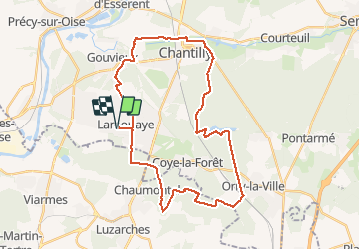
Trail Mountain bike of 34 km to be discovered at Hauts-de-France, Oise, Lamorlaye. This trail is proposed by domifon.
Description
Zone humide au sud de Coye impossible a franchir si pluie
Positioning
Country:
France
Region :
Hauts-de-France
Department/Province :
Oise
Municipality :
Lamorlaye
Location:
Unknown
Start:(Dec)
Start:(UTM)
457610 ; 5445154 (31U) N.
Comments