


Belgentier/Carnoules

CABERMAT
User
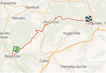

Length
25 km

Max alt
698 m

Uphill gradient
1119 m
Km-Effort
40 km

Min alt
156 m

Downhill gradient
1082 m
Boucle
No
Creation date :
2020-06-06 07:39:38.628
Updated on :
2020-06-06 19:36:06.499
8h00
Difficulty : Very easy

FREE GPS app for hiking
 SityTrail
IGN / Geographical institutes
SityTrail Plus
The world is yours!
About
Trail Walking of 25 km to be discovered at Provence-Alpes-Côte d'Azur, Var, Belgentier. This trail is proposed by CABERMAT.
Positioning
Country:
France
Region :
Provence-Alpes-Côte d'Azur
Department/Province :
Var
Municipality :
Belgentier
Location:
Unknown
Start:(Dec)
Start:(UTM)
743517 ; 4792528 (31T) N.
Comments