


Fond des 4 vaux

PhilippeC54
User
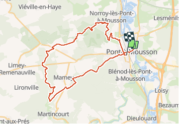

Length
35 km

Max alt
383 m

Uphill gradient
528 m
Km-Effort
42 km

Min alt
173 m

Downhill gradient
523 m
Boucle
No
Creation date :
2020-06-07 06:10:05.026
Updated on :
2020-06-07 09:43:49.176
2h41
Difficulty : Very easy

FREE GPS app for hiking
 SityTrail
IGN / Geographical institutes
SityTrail Plus
The world is yours!
About
Trail Mountain bike of 35 km to be discovered at Grand Est, Meurthe-et-Moselle, Pont-à-Mousson. This trail is proposed by PhilippeC54.
Positioning
Country:
France
Region :
Grand Est
Department/Province :
Meurthe-et-Moselle
Municipality :
Pont-à-Mousson
Location:
Unknown
Start:(Dec)
Start:(UTM)
283586 ; 5420424 (32U) N.
Comments