


Urcerey

alexbnmr
User
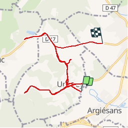

Length
13.8 km

Max alt
460 m

Uphill gradient
217 m
Km-Effort
16.6 km

Min alt
365 m

Downhill gradient
196 m
Boucle
No
Creation date :
2014-12-10 00:00:00.0
Updated on :
2014-12-10 00:00:00.0
1h44
Difficulty : Unknown

FREE GPS app for hiking
 SityTrail
IGN / Geographical institutes
SityTrail Plus
The world is yours!
About
Trail Other activity of 13.8 km to be discovered at Bourgogne-Franche-Comté, Territoire-de-Belfort, Argiésans. This trail is proposed by alexbnmr.
Points of interest


Positioning
Country:
France
Region :
Bourgogne-Franche-Comté
Department/Province :
Territoire-de-Belfort
Municipality :
Argiésans
Location:
Unknown
Start:(Dec)
Start:(UTM)
335662 ; 5274912 (32T) N.
Comments