


GRP Luberon Tour des Clapaèdes 42km

thonyc
User GUIDE
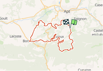

Length
42 km

Max alt
892 m

Uphill gradient
1385 m
Km-Effort
61 km

Min alt
229 m

Downhill gradient
1384 m
Boucle
Yes
Creation date :
2020-06-08 14:14:56.629
Updated on :
2020-07-19 09:45:41.405
14h47
Difficulty : Difficult

FREE GPS app for hiking
 SityTrail
IGN / Geographical institutes
SityTrail Plus
The world is yours!
About
Trail Walking of 42 km to be discovered at Provence-Alpes-Côte d'Azur, Vaucluse, Saignon. This trail is proposed by thonyc.
Positioning
Country:
France
Region :
Provence-Alpes-Côte d'Azur
Department/Province :
Vaucluse
Municipality :
Saignon
Location:
Unknown
Start:(Dec)
Start:(UTM)
693266 ; 4857552 (31T) N.
Comments